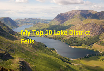
Sour Howes (64), Sallows (65) and Troutbeck Tongue (66) Walk from Troutbeck Jesus Church
To start with, I've decided to number the Wainwrights I take in as part of any of my walks so that I can keep a running total of where I am up to and as to not render my original post completely obsolete.
Today's walk starts from the parking area on Green Gate just off the A592 Kirkstone Pass and next to Troutbeck, Jesus Church. There's room here for approximately 8 cars so I'd suggest getting there early would secure you a parking place. There is some on road parking nearby and on the A592 itself but this 'car park' is by far the best option, and free.
Head from the car park and turn right onto the A592. There's a little footbridge to take you over Trout Beck itself, allowing you to avoid the road which then leads you onto a footpath along the road. At this point you will be able to see the start of the path onto the fells just across the road and to your left.
It's fairly easy going to start with and navigation is not a problem. Just stay on this path through the wooded area until it opens up.
You'll pass a gate at a fork in the path on your left that takes you down past Limefitt Holiday Park. This is the way I took later on to get to Troutbeck Tongue.
Continuing along the path and a little further on, you arrive at a stile over the wall and this is your route up on to Sour Howes and the open fells. The path takes you quickly to another stile and then on towards a rocky outcrop further up.
The path is fairly easy to follow through the grass but does now steepen up some what. I took the opportunity here to stop and take pictures of the views that where starting to appear!
The path rises steadily with little undulations making you work a little harder. There's a small beck to cross and the ground was a little soft underfoot after a couple of days of heavy rain but the worst parts were easily avoided (I'm not a fan of marshy or boggy ground and avoid it whenever possible)
A little more effort and the summit of Sour Howes comes into view. I would have said becomes obvious but its not the case. There's a few mounds and peaks that all look of similar height but there's a pike shown below that is the summit. It doesn't help that the summit cairn that consisted of a handful of rocks has now gone but I confirmed the top with the help of a couple of apps on my phone.
I didn't hang around here long at all and after saying hi to a passing fell runner, ahead on wards over to Sallows. Again it's clear enough path and you then pick up a stone wall to follow which curves around the ridge.
You eventually reach a stile over the wall and this then leads you up onto Sallows. It's not too steep and is only a short pull onto the top. I had a little chat here just before the summit to an older couple who where up there to bag a few Wainwrights but seemingly had no plan which ones to climb. I suggested Sallows and Troutbeck Tongue or even Wansfell then headed on my way.
Again, like Sour Howes, the summit of Sallows has no summit cairn but the first 'hump' you arrive at is the summit. There's another hump just past here so I wondered over just to be sure but it was obvious looking back the first hump was the higher of the two.
From the summit there is a path the that heads roughly north taking you down Garburn Road. This path leads from Kentmere in the east over to the start of this walk at Troutbeck. You emerge onto the path over another stile and head west to follow the path back down. Here you pass a cairn and the start of the western half of the Kentmere Horseshoe leading firstly up on to Yoke.
It was on this descent that I was in two minds what to do. My original plan was to climb Troutbeck Tongue which I then changed the day before when I thought I'd go over and climb Wansfell instead but I kept looking over to Troutbeck Tongue and changed my mind again as it looked too tempting. I'd checked my maps and apps before coming and I couldn't see any clear way to cut across from Garburn Road into the valley to lessen the length of the walk and as I was walking alone today and didn't want to get myself in to any trouble with possible boggy ground after the rain, decided to head back to the gate I'd passed earlier in the walk and start the 6k walk in back down to The Tongue!
The walk down the valley is straight forward enough following a well defined path passing the occasional farm and a riding school. There was also a couple waterfalls dropping off from the sides of Yoke.

Just before the start of the steep climb up the ridge another stile is crossed before heading left over a bridge across a beck before crossing another stile which seemed really high, maybe I was just a little tired by now! I took it slow and steady and eventually arrived at a gate which can be seen from along the valley. At this point I checked ViewRanger and worked out I had just short of 100 metres of ascent left to climb.
The ridge thankfully begins to slowly level out from the gate on wards and soon enough the summit cairn comes in to view.
Upon reaching the top it was time to take in the views of the higher fells around me and also to have a little bite to eat in readiness for the descent and the long walk back down the valley. Troutbeck Tongue is like a little island being surrounded by the valley and then the higher fells all around it, offering great views.
After descending down, I followed a different path back down the valley which is the first path you reach and before the bridge you crossed a little earlier on. Don't cross back over just head south down the valley on this path. You can follow it straight back down on to the Kirkstone Pass and from there it's a short walk along the road back to start of the walk.
I was in a bit of a rush to get back home by now and was gutted I couldn't go and have a look at the pubs in Troutbeck, The Mortal Man and The Queens Head, but I plan on returning and checking out what beer and food both have to offer.
As mentioned earlier, it also possible to climb Wansfell Pike and Baystones (this is the Wainwright Top) on Wansfell from the same starting point and it would also be easy to split this walk into two and climb Sour Howes and Sallows separately from Troutbeck Tongue.
If you've enjoyed reading this post please like, subscribe and share.
 |
| This route totalled 17 km or just over 10 miles. |
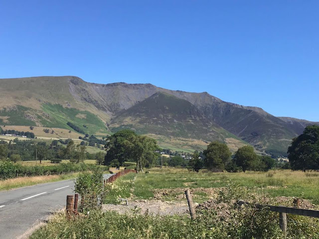
Today's walk starts from the parking area on Green Gate just off the A592 Kirkstone Pass and next to Troutbeck, Jesus Church. There's room here for approximately 8 cars so I'd suggest getting there early would secure you a parking place. There is some on road parking nearby and on the A592 itself but this 'car park' is by far the best option, and free.
Head from the car park and turn right onto the A592. There's a little footbridge to take you over Trout Beck itself, allowing you to avoid the road which then leads you onto a footpath along the road. At this point you will be able to see the start of the path onto the fells just across the road and to your left.
 | |
| Start of the track leading to the fell. |
It's fairly easy going to start with and navigation is not a problem. Just stay on this path through the wooded area until it opens up.
 | |
| The trees begin to thin out toward the open fells. |
You'll pass a gate at a fork in the path on your left that takes you down past Limefitt Holiday Park. This is the way I took later on to get to Troutbeck Tongue.
Continuing along the path and a little further on, you arrive at a stile over the wall and this is your route up on to Sour Howes and the open fells. The path takes you quickly to another stile and then on towards a rocky outcrop further up.
 | |
| Troutbeck Tongue seen from near the stile onto the fells. |
 |
| Looking across Troutbeck Village to a cloudy Wansfell. |
 | |||
| Stile onto the fell. You can see the 2nd stile and the rocky outcrop ahead on the path. |
The path is fairly easy to follow through the grass but does now steepen up some what. I took the opportunity here to stop and take pictures of the views that where starting to appear!
 |
| Lake Windermere. |
The path rises steadily with little undulations making you work a little harder. There's a small beck to cross and the ground was a little soft underfoot after a couple of days of heavy rain but the worst parts were easily avoided (I'm not a fan of marshy or boggy ground and avoid it whenever possible)
A little more effort and the summit of Sour Howes comes into view. I would have said becomes obvious but its not the case. There's a few mounds and peaks that all look of similar height but there's a pike shown below that is the summit. It doesn't help that the summit cairn that consisted of a handful of rocks has now gone but I confirmed the top with the help of a couple of apps on my phone.
 |
| Sour Howes summit. |
I didn't hang around here long at all and after saying hi to a passing fell runner, ahead on wards over to Sallows. Again it's clear enough path and you then pick up a stone wall to follow which curves around the ridge.
 | |
| Stone wall curving along the ridge over to Sallows. |
You eventually reach a stile over the wall and this then leads you up onto Sallows. It's not too steep and is only a short pull onto the top. I had a little chat here just before the summit to an older couple who where up there to bag a few Wainwrights but seemingly had no plan which ones to climb. I suggested Sallows and Troutbeck Tongue or even Wansfell then headed on my way.
 |
| The short pull up onto Sallows passed the stile. |
Again, like Sour Howes, the summit of Sallows has no summit cairn but the first 'hump' you arrive at is the summit. There's another hump just past here so I wondered over just to be sure but it was obvious looking back the first hump was the higher of the two.
 |
| The summit of Sallows looking back over to Sour Howes. |
From the summit there is a path the that heads roughly north taking you down Garburn Road. This path leads from Kentmere in the east over to the start of this walk at Troutbeck. You emerge onto the path over another stile and head west to follow the path back down. Here you pass a cairn and the start of the western half of the Kentmere Horseshoe leading firstly up on to Yoke.
 |
| The path leading to Yoke and the Kentmere Horseshoe. |
It was on this descent that I was in two minds what to do. My original plan was to climb Troutbeck Tongue which I then changed the day before when I thought I'd go over and climb Wansfell instead but I kept looking over to Troutbeck Tongue and changed my mind again as it looked too tempting. I'd checked my maps and apps before coming and I couldn't see any clear way to cut across from Garburn Road into the valley to lessen the length of the walk and as I was walking alone today and didn't want to get myself in to any trouble with possible boggy ground after the rain, decided to head back to the gate I'd passed earlier in the walk and start the 6k walk in back down to The Tongue!
 |
| The Tongue way down the valley. |
The walk down the valley is straight forward enough following a well defined path passing the occasional farm and a riding school. There was also a couple waterfalls dropping off from the sides of Yoke.

 |
| Lovely waterfalls running off Yoke! |
Just before the start of the steep climb up the ridge another stile is crossed before heading left over a bridge across a beck before crossing another stile which seemed really high, maybe I was just a little tired by now! I took it slow and steady and eventually arrived at a gate which can be seen from along the valley. At this point I checked ViewRanger and worked out I had just short of 100 metres of ascent left to climb.
 |
| Not far to go. |
The ridge thankfully begins to slowly level out from the gate on wards and soon enough the summit cairn comes in to view.
 |
| The Tongues summit cairn. |
Upon reaching the top it was time to take in the views of the higher fells around me and also to have a little bite to eat in readiness for the descent and the long walk back down the valley. Troutbeck Tongue is like a little island being surrounded by the valley and then the higher fells all around it, offering great views.
 |
| Wansfell. |
 |
| Red Screes across Kirkstone Pass. |
 |
| Ill Bell. |
 | |
| Looking back to Windermere. |
After descending down, I followed a different path back down the valley which is the first path you reach and before the bridge you crossed a little earlier on. Don't cross back over just head south down the valley on this path. You can follow it straight back down on to the Kirkstone Pass and from there it's a short walk along the road back to start of the walk.
I was in a bit of a rush to get back home by now and was gutted I couldn't go and have a look at the pubs in Troutbeck, The Mortal Man and The Queens Head, but I plan on returning and checking out what beer and food both have to offer.
As mentioned earlier, it also possible to climb Wansfell Pike and Baystones (this is the Wainwright Top) on Wansfell from the same starting point and it would also be easy to split this walk into two and climb Sour Howes and Sallows separately from Troutbeck Tongue.
If you've enjoyed reading this post please like, subscribe and share.
Comments
Post a Comment